Saturday, April 18, 2009

The new valley project

The new valley project:
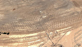
The New Valley Project in southern Egypt is one of the biggest irrigation projects ever constructed. It consists of a system of canals to carry water from Lake Nasser to irrigate the sandy wastes of the Western Desert of Egypt, which is part of the Sahara Desert. The 310-km long Sheikh Zayed canal is the biggest canal of the project and should bring 25 million m3 of water per day into one of the most inhospitable desert on earth and create a new Nile delta. These canals are build in the middle of this desert in the hot sun. First, the channels are dug in the middle of the desert sand:


After that the first layer of concrete is poured on it:


After this layer another layer of conrete is poured on it but first they attach layers of plastic foils in between so they don't lose any water:


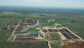
Of course these channels have to be filled with water. This is where the flagship of this project comes in action. I'm talking about the Mubarak Pumping Station which is described as a venture which "has expanded the boundaries of civil engineering. It is pumping water from from Lake Nasser into the channels. It has a discharge capacity of 1.2 million m³/hr making it the largest water pump in the world. Its innovative design places the pump-house like an island in a lake - completely surrounded by water with 24 vertical pumps arranged in two parallel lines along both sides. You can see how large this pump is when it was under construction and not filled with water around it yet:


When the water was filled around it it looks like this: (The structure itself is continuing 50 meters under water):


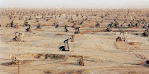
When this thing has done it's job the channels are filled with water making agriculture in the middle of
one of the most inhospitable deserts on earth possible:

Read more...

Sunday, April 12, 2009

The stairway to heaven

The stairway to heaven
The Chinese call the stairway you see in the two pictures below "the heaven reaching ladder". It must be one of the most impressive external staircases in the world:


The staircase is part of the Tianmen Mountain (which is only 8 kilometers away from downtown Zhangjiajie), and leads to the Tianmen cave which offers a great view over the nearby mountains and is a religious site for praying for happiness. This open cave is already visible from far away:


There are altogether exactly nine hundred and ninety-nine steps in this staircase. This Tianment cave is a natural water-eroded cave with the highest elevation in the world. The open cave runs south-northward and has a height of 131.5 meters, a width of 57 meters and a depth of 60 meters. It’s much like a gate towards the heaven. In 1999 a bunch of pilots flied their jets trough this c
ave. This event was watched by 800 million people on tv.
And in 2006 the Russian Air force did the same (the picture seen below is not photoshopped):


By the way not only this staircase and cave are impressive also the road leading to this place is fascinating. This road is called the Tongtian Avenue (Avenue toward Heaven) and it has 99 turns symbolizing that the heaven has nine palaces:
'


Read more...

Cool exterior elevators

Cool exterior elevators:
The Bailong Elevator is the world’s largest exterior elevator built onto the side of a huge cliff in Zhangjiajie in China. At over 330 meters tall, this elevator looms high midway up a cliff overlooking a valley far below. Moreover, the elevator is mostly glass, affording passengers a dizzying view to the depths below:


The Hammetschwand Lift is the highest exterior elevator of Europe and is located in Switzerland. It brings you 156 meters in the air from a spectacular rock path to the lookout point Hammetschwand on the Bürgenstock plateau overlooking Lake Lucerne:


These kind of exterior lift are sometimes also integrated in buildings like here in the Lacerda building in the city of Salvador in Brazil:


This thing takes you up 72 meters, and at the top you have a great view over the nearby bay.

Read more...

Saturday, April 11, 2009

Deforestation of the Amazon rainforests

Deforestation of the Amazon rainforests:
There is no such species rich rainforest on the earth as the Amazon rainforest in northern South America, but there is also no rainforest where the deforestation is so massive and also so well visible from satellite images. The jungle here is typically cleared to provide pasture for cattle, then soy farmers move in later, and after the soy is not profitable anymore they cultivate their crops. In all the state that are part of the Amazone forest the deforestation is best visible in the state of Mato Grosso in Brazil. 48 percent of Amazon deforestation that took place last years occurred in Mato Grosso. Take for example this satellite image from google earth:


In 1992 this was one big forest, but now you see that the dark green color of the wood is largely taken over by agriculture. This is also the case in the state of Rondonia in Brazil. About 50 percent of the Amazon forest is felled here during the past 20 years:


The States of Amazonas and Para that cover most of the amazon forest are still largely covered by forest. But also here are large-scale logging projects going on. This happens usually along a main road from where the rain forest continues to be cut away. This creates an elongated form as you can see in the picture below in the state of Para:


In the picture below you can see this deforestation process in an earlier state in the Amazone state of Brazil:


In eastern Bolivia this deforestation is also done in some sort of agriculture circular crops to get the most efficient possible format for the farmers:


Not only humans are responsible for the deforestation of the Amazone forest. Often large forest fires occure. The most notable was the "Great Fire" that occurred in Roraima in 1998 and whose scars are still visible in the landscape:


The area in the picture above measures about 70 km by 120 km. This natural process is ,contrary to human logging, of course not damaging for the forest in the long term. If the human deforestation of this forest goes on in the same rate as now the Amazone rain forest will be 85% gone in the next 100 years. This could cause much more extreme weather on the planet and would contribute to the global warming. And maybe even more worse the loss of countless species and potential drugs against various diseases.

Read more...

Largest cooling towers

Largest cooling towers:
Cooling towers are heat removal devices used to transfer process waste heat to the atmosphere. These cooling towers are found at really big dimensions at most power plants. The primary use of large, industrial cooling towers is to remove the heat absorbed in the circulating cooling water systems used in power plants. These things have to be so big to be able to cool the water in a constant rate. If these things are not used you need an enormeous amount of cooling canals which for example can be seen at the Turkey point power plant in Florida.

The world's tallest cooling tower is the 200 meter tall cooling tower of Niederaussem Power Station in Germany. The skyline of the villages nearby are all dominated by this thing:


The cooling towers of the Belleville nuclear power plant in Billeville sur Loire in France are also giants. These cooling towers are 150 meters in diameter at the base, and are about 170 meters high:


These things were climbed by Greenpeace activists in 2007 as you can see in the pictures below. This way you can easily estimate how big these structures are:


Even the open structure at the base is taller then you would think:


Other huge cooling towers can be seen (not yet visible in google maps) at the new expansion of the Neurath Power station in Germany which was recently completed. The 2 cooling towers here are each 170 meters tall:


The cooling towers during construction:


Read more...

Friday, April 10, 2009

The "elephant cages"

The "elephant cages":

Elephant cages are what they called or in normal terms the Wullenwebers or the FLR-9 antennas (the original name introduced by Dr. Hans Rindfleisch was Wullenwever). I talk about the circularly disposed antenna arrays built by the United States during the 1960s. These are large circular antenna arrays used by the military to triangulate radio signals for radio navigation, intelligence gathering and search and rescues. Because of the immense sizes (370 meters in diameter and 40 meters high) and huge circular reflecting screens, the antennas are colloquially known as the elephant cages. In total there are 8 of these huge FLR-9 antennas build, spread over the world. They were constructed at:

-Augsburg, Germany. This one is not in use anymore:


-Chicksands, United Kingdom ( not in use anymore):


-Clark AFB, Philippines. As you can see in the picture below this elephant cage has been converted to a 35,000-seat fabric-covered amphitheatre:


-Elmendorf AFB, Alaska. This one is still operational:


- Karamursel, Turkey. This one is already overgrown by vegetation and is the least visible one. It looked identical as the other ones.

- Misawa, Japan. This antenna is still active also:


-Ramasun, Thailand (This one is not visible in google maps in highress).

-San Vito dei Normanni, Italy:


As you can see in the pictures above all of these antennas excist of two major rings of HF antennaes. The outer ring is for monitoring shorter HF wavelengths and is is about 370 meters in diameter and contains some 120 sleeve monopoles. The inner ring is for monitoring Longer wavelength signals, and is typically some 100 meters in diameter with some containing 40 folded dipoles. A horizontal ground screen about 400 meters in diameter surrounds the entire site. The station's intercept operators work in an operations building in the center of the array.

Read more...

Thursday, April 9, 2009

The biggest "slide" in the world

The biggest "slide" in the world:
Dam spillways are used to release water in case of a flood, but sometimes these spillways are also used as a slide for kayakers and even bikes. This is the case with Europe's largest dam spillway which is part of the LIyn Brianne dam in Wales:


This concrete monster the size of a main road plunges more than 330 meters to the valley below. It makes one of those terrifying Olympic ski jumps look like a speed bump. Standing on the public walkway at the top, looking down, is mesmerising and slightly nauseating. The water goes from looking-glass calm, over a lip, on to a shelf and then crashes down the slope, forming a beautiful foaming latticework all the way down:


It cannot be overstated that it is madness to contemplate any sort of trip down Llyn Brianne, but still it is used by kayakers (and even bikers).


These kayakers take the risk of being forced under water and thrown around like a pair of socks in a washing machine. Let's say it not a thing you want to plan for a vacation holiday.

Read more...
Blog Widget by LinkWithin

  © Blogger templates ProBlogger Template by Ourblogtemplates.com 2008

Back to TOP